Unitree L1 Pm Lidar (Precision Measurement) (LIDAR-L1-PM)
In stock
- BRAND:
- UNITREE ROBOTICS
- PART #:
- LIDAR-L1-PM
- ORIGIN:
- China
- AVAILABILITY:
- SUBJECT TO AVAILABILITY
- SKU:
- Unitree-LIDAR-L1-PM
Unitree L1 Pm Lidar (Precision Measurement) (LIDAR-L1-PM)
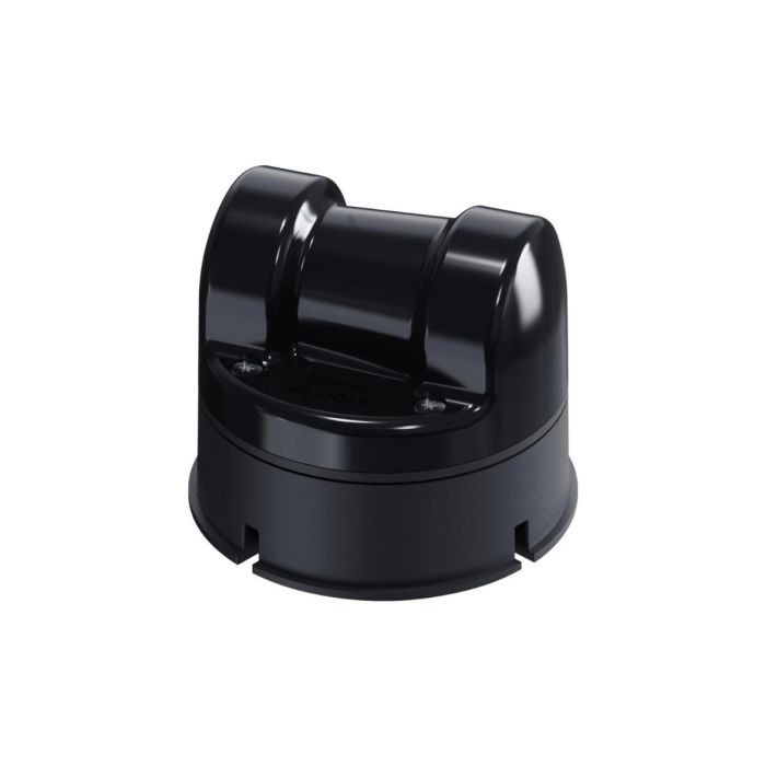
Some sensors earn their place by being impressive; others by being easy to forget about once they are bolted on. The Unitree L1 Pm Lidar (Precision Measurement) (LIDAR-L1-PM) is meant for the second group: a 4D LiDAR that weighs 230g and measures 75×75×65mm, so a robot can carry it without redesigning the rest of the machine around it. It reports three-dimensional position plus a grayscale value for every return, and it does so over a field of view of 360°* 90°.
The product is available through this page, by quotation.
Background
Unitree and its LiDAR line
Unitree Robotics is a robotics manufacturer best known for its legged and humanoid platforms. Those machines need to know where the floor, the walls and the obstacles are, so it is natural that the company also offers sensing hardware of its own. The LiDAR family sits alongside the robots in the catalog and is collected in the Unitree Lidar category, where buyers can compare it with other scanners used on Unitree platforms.
Within that family, the L1 is offered in two versions. The L1 PM, the subject of this page, is the Precision Measurement version. The other is the L1 RM (Remote Measurement), which has its own page: Unitree L1 Rm Lidar (Remote Measurement) (LIDAR-L1-PM-RM). The names alone tell a buyer which way each version leans, and this page gives only the figures for the PM.
Positioning and key technology
The L1 is a cost-effective, safe and reliable 4D LiDAR. The fourth dimension is a grayscale value attached to each point, alongside the three-dimensional position. Grayscale gives software a second clue about a surface, which can help when distinguishing one object from another in a cloud of points.
The sensor works with a 905nm laser and is rated Eye Safety Class 1 under IEC60825-1:2014. That rating matters for anyone planning to run the sensor in rooms where people work, teach or pass by. Data leaves the unit over a TTL UART communication interface, a simple serial link that most embedded controllers and single-board computers can read.
Technical Specifications
| Specification | Value |
|---|---|
| Version | L1 PM (Precision Measurement) |
| Data type | 4D LiDAR (3D position + 1D grayscale) |
| Field of view (FOV) | 360°* 90° |
| Sampling frequency | 43200 points/s |
| Effective frequency | 21600 points/s |
| Measurement accuracy | ±2.0cm |
| Vertical scanning frequency | 180Hz |
| Communication interface | TTL UART |
| Laser wavelength | 905nm |
| Eye safety | Class 1 (IEC60825-1:2014) |
| Weight | 230g |
| Size | 75×75×65mm |
Specifications as published by the manufacturer; confirmed against the datasheet at quotation.
The manufacturer has not published the payload compatibility list, the point cloud output format details, the cable length or the shock and vibration rating; they are confirmed at quotation.
What makes the L1 PM different from the L1 RM?
The two versions share a family name, and a buyer choosing between them is really choosing what the sensor is tuned to do. The PM is the Precision Measurement version. This version has a measurement accuracy of ±2.0cm, and that figure belongs to the PM alone. It should not be carried over to the RM.
The RM is the Remote Measurement version. This page carries no figures for it, so it makes no comparison of range or accuracy between the two. If your project depends on how the two differ in reach, ask about the RM when you request a quotation. The RM page linked above is the place to start that comparison.
How does a 4D LiDAR differ from a camera or a flat scanner?
A camera infers distance from perspective and shading; a laser scanner measures it directly. A flat, single-plane scanner measures well along one slice of space but says nothing about what sits above or below that slice. The L1 PM sweeps a field of view of 360°* 90° with a vertical scanning frequency of 180Hz, so it gathers points in three dimensions rather than in one plane.
The grayscale channel adds information that distance alone cannot carry. Two surfaces at the same distance can return different grayscale values, which gives mapping and perception software another handle on the scene. The sampling frequency is 43200 points/s and the effective frequency is 21600 points/s; those are the two point rates of this sensor, and a team planning its processing load should design around both.
Who is the Unitree L1 Pm Lidar for?
Robotics researchers are the most obvious buyers. A sensor of 230g with a TTL UART output is easy to place on an experimental platform, and a 4D point cloud is a good starting point for mapping, localization and obstacle-avoidance work.
Universities and training programs will find the Class 1 eye safety rating reassuring where students work close to the hardware. System integrators building inspection or service robots can use the compact 75×75×65mm body to keep the mounting simple. Teams that work with Unitree machines should also look at the Accessories category when planning a full system, and those whose use case leans toward distance rather than precision should read about the L1 RM first.
Buyers who need a larger or different scanner for a particular Unitree robot can compare other LiDAR options in the catalog, such as the Unitree H2 LiDAR Package or the Unitree G1 Livox Mid360 Lidar (G1-MID360L).
What is the Unitree L1 Pm Lidar used for?
- Mapping indoor spaces. The 360°* 90° field of view collects points around the robot for building a three-dimensional map.
- Obstacle avoidance. Direct laser distance measurement lets a mobile robot detect objects in its path.
- Robot localization. A stream of 4D points gives positioning software a reference to match against a known map.
- Research and teaching. A compact unit with a serial interface suits laboratory benches and student projects.
- Perception experiments. The grayscale value attached to each point supports work that combines shape and surface information.
- Integration into custom platforms. The small body and 230g weight make it practical to add to a machine that was not designed around a LiDAR.
Pricing and Availability
No price is printed on this page, because each order is quoted against the configuration and the destination. Request a quotation and we will go through the details with you. Delivery, customs and support are arranged together with the quotation. The Unitree L1 Pm Lidar (Precision Measurement) (LIDAR-L1-PM) is available on this page.
Frequently Asked Questions
What does 4D mean for this LiDAR?
It is a 4D LiDAR made of 3D position plus 1D grayscale. Each point therefore carries a location and a grayscale value.
What is the field of view?
The field of view is 360°* 90°. The vertical scanning frequency is 180Hz.
How accurate is the L1 PM?
The measurement accuracy is ±2.0cm. That figure is for the L1 PM (Precision Measurement) version.
How does it connect to a controller?
It uses a TTL UART communication interface. Ask about the cable length when you request a quotation.
Is it safe for use around people?
The sensor carries an Eye Safety rating of Class 1 under IEC60825-1:2014 and uses a 905nm laser.
How big and how heavy is it?
It measures 75×75×65mm and weighs 230g.
Where can I buy the Unitree L1 Pm Lidar and what does it cost?
You can buy it through this page by requesting a quotation. The cost is given in that quotation, together with delivery, customs and support arrangements.
Summary
The Unitree L1 Pm Lidar (Precision Measurement) (LIDAR-L1-PM) is a sensor that asks little of the robot carrying it: 230g, 75×75×65mm, a serial interface and a Class 1 eye safety rating. In return it offers a 4D point cloud over a 360°* 90° field of view, at 43200 points/s with an accuracy of ±2.0cm. For researchers, educators and integrators who want precise measurement without a heavy sensor, this page is the starting point.
Specifications
General
What's included
Related Products
Out of stock