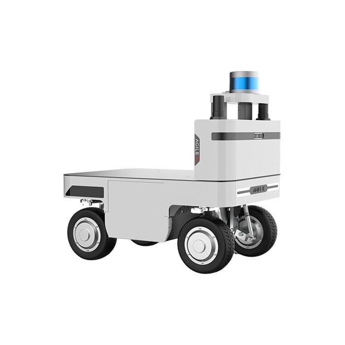
Agilex NAVIS Autonomous Navigation System
In stock
- BRAND:
- AGILEX
- PART #:
- NAVIS
- ORIGIN:
- China
- AVAILABILITY:
- SUBJECT TO AVAILABILITY
- SKU:
- AgileX-NAVIS
Agilex NAVIS Autonomous Navigation System
A robot that cannot find its way is only a cart with motors. The Agilex NAVIS Autonomous Navigation System is built to change that: it gives a mobile platform a sense of place, a map to follow and the judgment to steer around whatever turns up in its path. Instead of asking an integrator to stitch together sensors, mapping tools and planning software, NAVIS brings them together in one navigation package designed for semi-enclosed and enclosed environments such as warehouses, plants and large indoor facilities.
The product is available through this page, by quotation.
Background
AgileX and the road to NAVIS
AgileX is a robotics manufacturer known for mobile robot platforms, and its catalog also reaches into robotic arms, kits and development tools. Over time, the company has seen that customers want more than a moving base. They want a base that can map a site, plan its own route and report what it is doing. NAVIS is the company's answer to that request, offered as a navigation layer that can be integrated into industrial robots and AGVs rather than a closed machine. You can see the wider range of the brand in the AgileX category.
How the system is positioned
NAVIS lets robots move on their own in semi-enclosed and enclosed spaces. It processes data from the sensors and systems on board and turns it into navigation decisions. Its approach rests on proprietary LiDAR-IMU sensor fusion, real-time path planning and adjustment, obstacle detection and avoidance, and intelligent decision-making algorithms. The sensor set combines solid-state LiDAR, depth and stereo cameras and an IMU.
The system is modular, built from NAVIS Brain, NAVIS Bridge and NAVIS Board, so it can be fitted to different UGV platforms. On the software side, NAVIS comprises three core components: the Navigation Panel, the Task Management System and the Visual Feedback System. Together they cover mapping, path planning, task management and fleet coordination.
Technical Specifications
| Specification | Value |
|---|---|
| Product type | Autonomous navigation system for semi-enclosed and enclosed environments |
| Mapping area | 2 mil. ㎡ |
| Positioning accuracy | approx. ±3-5 cm |
| Maximum navigation speed | up to approx. 2.5 m/s |
| Repeat position accuracy | ±8cm |
| Travel positioning accuracy | ±10cm |
| Navigation method | Proprietary LiDAR-IMU sensor fusion, real-time path planning and adjustment, obstacle detection and avoidance |
| Sensors | Solid-state LiDAR, depth/stereo cameras, IMU |
| Modules | NAVIS Brain, NAVIS Bridge, NAVIS Board |
| Core components | Navigation Panel, Task Management System, Visual Feedback System |
| Mapping | One-Click Mapping with real-time map editing |
| Safety features | Collision avoidance, virtual barriers, emergency stop |
| Integration | SDK, API and ROS2 compatibility |
Specifications as published by the manufacturer; confirmed against the datasheet at quotation. The manufacturer has not published the dimensions, the weight, the power supply, the power consumption, the LiDAR model and range, the camera resolution, the operating temperature, the IP rating, the communication interfaces or the list of supported chassis; they are confirmed at quotation.
What makes NAVIS different from a bare sensor kit?
A sensor kit gives you data and leaves the rest to you. NAVIS goes further, because the mapping, planning, task handling and monitoring tools come with the sensing. One-Click Mapping covers the site, and the system can map an area of 2 mil. ㎡. If the layout changes, real-time map editing tools let an operator adjust the map on the fly, without a full re-survey, to account for environmental changes or operational requirements.
The sensor fusion matters as well. Solid-state LiDAR, depth cameras and an IMU work together, so the robot does not rely on a single source of information. Positioning accuracy is approx. ±3-5 cm, and the system can navigate at up to approx. 2.5 m/s. Repeat position accuracy is ±8cm and travel positioning accuracy is ±10cm, figures that help a planner judge how the system suits docking, shuttle runs and route-based work.
How does NAVIS keep people in control?
Autonomy is only useful when operators trust it. NAVIS includes remote control that allows immediate human intervention or guidance when necessary, which supports both flexibility and safety. Collision avoidance, virtual barriers and an emergency stop add protection on the robot itself.
The Visual Feedback System and the custom data dashboard keep the operator informed. The dashboard works on a desktop or a mobile device, so supervisors can follow real-time insights and run on-the-fly analytics from wherever they are. For integrators, the SDK, API and ROS2 compatibility, supported by implementation guides and technical support, make it possible to build NAVIS into industrial robots and AGVs and to connect it to existing software.
Who is NAVIS for?
Robot manufacturers and system integrators are the clearest audience. They have a platform that moves well and need a proven navigation layer, without years of in-house development. NAVIS suits them because it arrives as modules with an SDK, an API and ROS2 compatibility.
Operators of warehouses, factories and other enclosed facilities also benefit, particularly those who want to deploy a robot, map the site quickly and change routes as the layout evolves. Research teams and universities working on UGV platforms can use it as a ready navigation base for their projects. Buyers who are still choosing a robot platform may wish to browse the AgileX range first, then ask us how NAVIS fits the chosen chassis.
What is NAVIS used for?
- Indoor transport. Moving goods along planned routes inside warehouses and production halls.
- Site mapping. Building a map of a large area with One-Click Mapping and refining it with the editing tools.
- Obstacle-aware driving. Detecting and avoiding people, equipment and loads that appear in the path.
- Task scheduling. Assigning and tracking jobs through the Task Management System, with fleet coordination.
- Remote supervision. Watching robots from the dashboard on a desktop or mobile device, and stepping in when needed.
- Platform integration. Embedding navigation into industrial robots, AGVs and UGV platforms through the SDK, API and ROS2.
Pricing and Availability
We do not print prices on this page. Please request a quotation, tell us about your platform and your site, and we will respond with a proposal. Delivery, customs and support are arranged together with the quotation. The Agilex NAVIS Autonomous Navigation System is available on this page.
Frequently Asked Questions
What environments does NAVIS work in?
NAVIS is designed for semi-enclosed and enclosed environments. It lets robots navigate them autonomously using data from the onboard sensors and systems.
Which sensors does it use?
It combines solid-state LiDAR, depth or stereo cameras and an IMU in a sensor fusion platform. This supports mapping, obstacle detection and navigation.
Can it be integrated into my own robot?
Yes. NAVIS offers an SDK, an API and ROS2 compatibility for industrial robots and AGVs, with implementation guides and technical support.
Can an operator take over a robot remotely?
Yes. Remote control allows immediate human intervention or guidance when necessary.
What safety features are included?
NAVIS offers collision avoidance, virtual barriers and an emergency stop.
What is in the delivery?
The scope of delivery is the NAVIS Brain, the main processing unit, together with a wiring harness and mounting accessories.
Where can I buy NAVIS and what does it cost?
You can buy the Agilex NAVIS Autonomous Navigation System through this page by requesting a quotation. The cost depends on your project, and we provide it in the quotation itself.
Summary
A robot gets far more useful once it can find its own way. The Agilex NAVIS Autonomous Navigation System supplies that ability: sensor fusion, One-Click Mapping, real-time planning, remote takeover and a dashboard, all open to integration through an SDK, an API and ROS2. For teams that want their platforms to move with confidence in enclosed spaces, this page is the starting point.